MEMORANDUM
To: Noise Compatibility Study Group, Navigation Committee
From: Eric Bernhardt
Subject: Draft Responses to Comments Regarding Annual Average Runway Use Assumptions, Louisville International Airport FAR Part 150 Noise Compatibility Study
The purpose of this memorandum is to provide responses to comments received in a September 3, 1999 memorandum from the Noise Compatibility Study Group, Navigation Committee regarding annual average runway use assumptions prepared for the Louisville International Airport FAR Part 150 Noise Compatibility Study (the Study).
Comment
The "assumed use" chart for modeling forecasts zero operations on Runway 11. Is this a result of its absence from the list of runway use configurations in the memo, or assumed weather factors, or both? We note that a couple of operations were in fact observed on this runway in the actual data.
Response
The reasons for this assumption is based on the fact that (1) Runway 11 is not included in the Airport’s formal runway use program, and (2) based on discussions with ATCT personnel, the annual use of Runway 11 is estimated to be less than 1.0%. Although we understand that some annual operations may occur on Runway 11 for air traffic control purposes or as a result of pilot requests, it is normal when preparing an aircraft noise analysis to not model operations on a runway when the average annual use is less than 1.0%. This limited use of Runway 11 was also confirmed by the fact that only 0.02% of the total operations included the ARTS data sample (2 operations out of 9,252 total operations) occurred on Runway 11.
Comment
The actual data also indicate deviations from the preferred runway configuration during the day at nearly double the rates estimated for modeling (e.g. on 35R, arrivals @ 12.1% observed, vs 6.3 estimated; departures @ 17.8%, vs 9.8; on 35L, arrivals @ 11.3%, vs 6.2; departures @ 7.4%, vs 4.0). This pattern seems large and systematic enough to demand a close look at its two possible sources:
Response
The deviation mentioned above are not deviations to the preferred runway use configurations delineated in the Airport’s informal runway use program, but are differences in the actual data collected in the four week sample of ARTS data and the assumed average annual runway uses which consider annual wind and weather conditions derived from actual weather data. Based on our review actual wind and weather data during the four week sample of ARTS data, wind originated from the north approximately 35% of the time thereby increasing the amount of operations on Runways 35R and 35L (north flow). Thus, the actual data in the ARTS sample included a higher percentage of operations on these runways than is normal over an annual basis, and was subsequently adjusted downwards based on average wind conditions over the last ten years. These differences are not at all unusual for partial year samples of ARTS data.
Comment
Design problems in compiling the estimates. A particular concern, for example, arises in the reduction of runway use factors other than average wind speed and direction to a naive decrement in the decision thresholds for tailwinds and crosswinds. Is there a logical basis for this substitution? What's the model's sensitivity to the specific values proposed? More to the point, are there no data available, through airport, government agency, or academic archives, on average incidence of wind shear, precipitation, runway maintenance requirements and the like, so that these factors could be represented directly for modeling purposes?
Response
In response to the questions proposed above, we have used available data to the maximum extent possible to prepare the annual average runway use assumptions. We have applied a standard approach and methodology which has been approved by the FAA in numerous aircraft noise analyses prepared by Leigh Fisher Associates.
Although we acknowledge that conditions such as wind shear, thunderstorms, and other severe weather influence average annual runway use, data on these severe conditions is almost impossible to relate back to runway use since a variety of other factors, including surface wind conditions and pilot/controller judgement are influential under such circumstances. In addition, although historic weather data may indicate that thunderstorm activity occurred in the Louisville area on a given date, the actual location and severity of the storm in relation to runway use configurations would remain unknown. Furthermore, there are a number of other factors that influence runway use for which there is no available data. For instance, our assumptions are based on historic hourly wind data, which again, is only a sample of the actual conditions occurring during each hour of measurement. Actual runway use assignments are determined by FAA air traffic controllers based on minute to minute surface wind conditions at the time of operation.
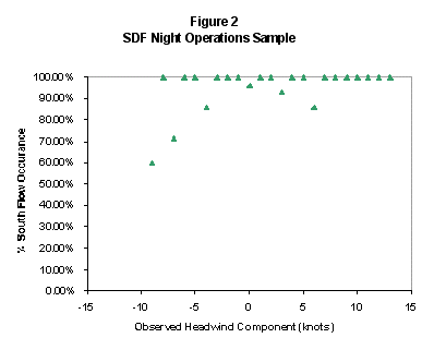
However, to verify our initial assumptions, specifically those related to the use of a 3 knot tail wind component to determine airfield runway use configurations, we have conducted a statistical correlation between actual wind conditions and actual runway uses during the ARTS data sample period. In this analysis we compared actual tail wind components with the observed direction of operations (i.e., north flow or south flow) for each hour during the ARTS sample period. Hourly observations were plotted on the histograms provided below.
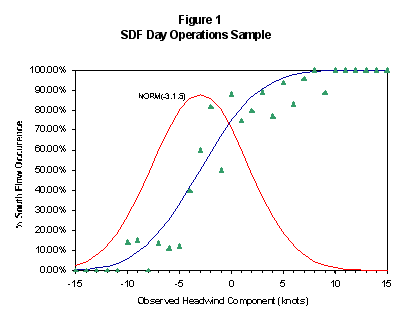
If anything, the data indicates that changes in runway use configurations are not discretely determined by allowable tail wind components alone. Rather, for any relative wind speed within the range of 10 knots tailwind ( negative 10 knot headwind as indicated in figures 1 and 2 ) to 10 knots headwind, there is the probability that either north or south flow may exist. This clearly indicates that other factors such as air traffic demand and fleet mix, also influence runway use configurations and whether a reversal in the flow direction would be required. Since these factors are very difficult to quantify, an adjusted tailwind component was used in the weather model to determine the occurrence of known annual runway use configurations used at the Airport .
Based on our experience at many airports over the years, and after a sensitivity analysis and coordination with FAA air traffic controllers, we determined that a 3 knot tailwind component was the best estimate as an input parameter to the weather model for daytime operations. For nighttime runway use we assumed a higher value of 5 knots since a larger percentage of heavier aircraft use the airfield during this time and wind conditions are generally calmer and not as variable. The resulting runway use percentages correlate well with the observed split between north and south flow at the airport.
By curve fitting a cumulative normal distribution through the data, and determining the mean value of the probability density function, these assumptions were confirmed for daytime operations (see Figure 1). However, for nighttime operations the data was inconclusive (see Figure 2). The ranges of tail wind components observed during night time were all relatively low, whereby no sufficient data was available at the extremities to verify any significant tendency. Again, all this proves is that many other factors other than wind speed alone are important in the determination of runway use configurations.
Comment
Anomalies in the observed data. The committee had anticipated in this memo a further elaboration of the specific conditions prevailing in the flight track data presented at the last Study Group meeting, and summarized in the "actual use" table. These data may have been skewed by unusual weather, maintenance, or other factors that would help justify using significantly different estimated values for modeling. We therefore remain hopeful of learning more about the ARTS sample.
By the same token, we hope to gain additional insights on the sub-sample of observations portrayed in the ARTS plots presented to the Study Group.
Response
The graphics of ARTS data presented at Study Group Meeting #2, included four days of data, and were depicted for presentation purposes only. Our intent was to demonstrate the following to Study Group members:
• How generalized flight tracks will be identified for noise modeling purposes
• Generalized altitudes for arriving and departing aircraft
• The ARTS data sample included operations on each of the Airport’s runway use configurations
Our approach has always been to prepare annual average runway use assumptions based on analysis of 10 years of wind data and the entire sample of ARTS data, not four sample days. Therefore, we have no reason at this time to analyzing small portions of the larger sample. Analyses of individual days in the sample could be conducted, but are outside of our current scope of work.
In regard to runway maintenance, we have reviewed Airport maintenance data provided by the RAA for the ARTS sample period. During the four week ARTS data sample, Runway 17R-35L was closed for a total of 24 hours on 6 separate occasions; Runway 17L-35R was closed for a total of 16 hours on 4 separate occasions. No unscheduled runway closures occurred during this time period. The closures that did occur were for routine off-peak maintenance and do not significantly affect the assumed average annual runway uses due to the overall sample size. Runway closures for maintenance purposes are scheduled at regular intervals throughout the year at the Airport. Therefore, their influence on the actual runway uses in the ARTS sample is reflected in the assumed averages.
Comment
The memo suggests, for example, that aircraft approaching visually would not appear on these plots; but there are many tracks far enough outside the prescribed pattern to be difficult to explain otherwise. We should seek clarification, however, on the memo's treatment of this point, in the third bullet under "ARTS Analysis Results", which we found very difficult to interpret.
Response
Aircraft performing visual approaches are included in the ARTS data sample so long as the aircraft did file an Instrument Flight Rules (IFR) flight plan at some point in the operations. In other words, aircraft that are cleared for a visual approach by the control tower but are IFR flights, are included in the sample.
The confusion caused by the third bullet in the original memorandum is due to a statement that is not entirely correct. The third bullet should explain that ARTS processing software does not capture aircraft that do not file an IFR flight plan, or those aircraft operating under Visual Flight Rules (VFR) flight plan. Since many GA aircraft that operate only under Visual Flight Rules (VFR) do not have to file a flight plan, they may not be captured.
Based on our experience conducting ARTS analyses at airports throughout the United States, the ARTS data sample obtained for this study is normal and does not include any anomalies. There do not appear to be any abnormal operations occurring outside of the prescribed pattern that require further investigation.
Comment
More generally, operational questions persist about the behavior of the sub-sample itself. On departures to the north, for example, if all flights on 35L are supposed to diverge left, why don't they? And if all on 35R should use runway heading, why don't they?
Response
It should be noted that the informal runway use procedures currently in place apply to all turbojet aircraft. Therefore, only turbojet aircraft departing on Runway 35L are required to turn to a 330 degree heading until reaching 3,000 feet MSL. Based on our review of the entire ARTS data sample, of a total 74 jet-other departures on Runway 35L, only 4 jet-other aircraft did not diverge to a 330 degree heading. The reason these aircraft did not perform the recommended noise abatement departure turn is unknown. Deviations from existing noise abatement procedures will be reviewed as part of this Study.
Departures on Runway 35R are to maintain the runway heading until 3,000 feet MSL. Based on our review of the ARTS data, the vast majority of aircraft did reach 3,000 feet MSL before turning on course. Again, deviations from existing noise abatement procedures will be reviewed as part of this Study.
Comment
Arriving flights from the north should be converging on runway heading by the time they reach the river, we think, but in the daytime plot look more like Eastern Parkway.
Response
There is no formal or informal requirement that specifies where aircraft should enter the arrival traffic patterns or turn to final approach. Based on our review of the entire ARTS sample, aircraft currently turn to a final approach to Runways 17R or 17L between southern Indiana and the approximate location of Eastern Parkway. Potential noise abatement arrival procedures will be analyzed in the Study during the review of potential alternatives.
Comment
The actual use table gives nighttime arrivals from the north less than 5% frequency on runway 17R, but on the plot it looks more like 50%. And at the most general level, how is it that such a large portion of arriving flights enter the area from the south, but almost none of the departing flights go that way?
Response
The graphics of ARTS data presented at Study Group Meeting #2 were depicted for presentation purposed only. Since we could not present the entire four week ARTS data sample, we selected two days of data that included winds from the south (use of Runways 17R and 17L) and two days of data that included winds from the north (use of Runways 35R and 35L). Therefore, it does appear that approximately 50% of arrival operations occurred on Runway 17R. Based on our review of the entire ARTS data sample, a total of 110 nighttime arrival operations (4.9%) occurred on Runway 17R.
In addition, our review of the ARTS data indicates that approximately equal portions of arrivals enter the Louisville airspace from the south, east, and west; and approximately equal portions of departures depart to the north, east, and west. Based on airspace restrictions associates with Fort Knox, aircraft departing to the south must turn either east or west after reaching the Louisville 270 degree radial.
EEB/eb
cc: Mr. William J. Willkie
Dr. William J. Dunlay
Dr. Evert Meyers
Mr. Leighton Quon
SDF Project Files 2.9.2, 6.2
Mr. Robert A. Brown, RAA